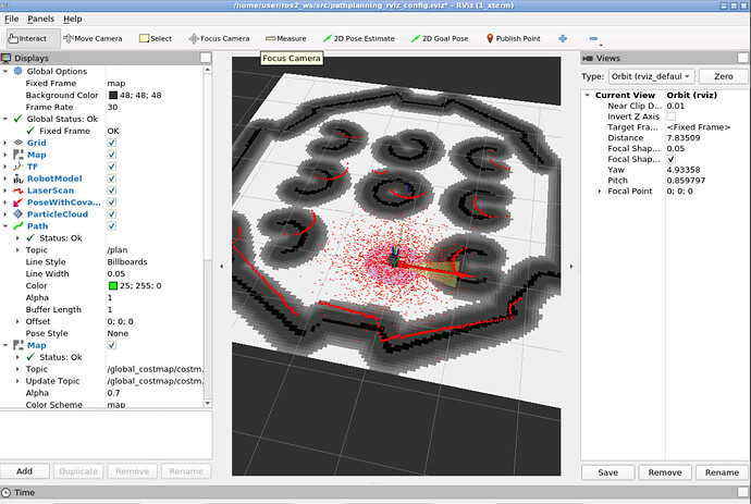
It doesnt seem to include the construction cone in the costmap. My planner_server file is as shown below:
planner_server:
  ros__parameters:
    expected_planner_frequency: 10.0
    use_sim_time: True
    planner_plugins: ["GridBased"]
    GridBased:
      plugin: "nav2_navfn_planner/NavfnPlanner"
      tolerance: 0.5
      use_astar: false
      allow_unknown: true
global_costmap:
  global_costmap:
    ros__parameters:
      update_frequency: 1.0
      publish_frequency: 1.0
      global_frame: map
      robot_base_frame: base_link
      use_sim_time: True
      robot_radius: 0.15
      resolution: 0.05
      track_unknown_space: true
      plugins: ["static_layer", "inflation_layer"]
      static_layer:
        plugin: "nav2_costmap_2d::StaticLayer"
        map_subscribe_transient_local: True
      obstacle_layer:
        plugin: "nav2_costmap_2d::ObstacleLayer"
        enabled: True
        observation_sources: scan
        scan:
          topic: /scan
          max_obstacle_height: 2.0
          clearing: True
          marking: True
          data_type: "LaserScan"
          raytrace_max_range: 3.0
          raytrace_min_range: 0.0
          obstacle_max_range: 2.5
          obstacle_min_range: 0.0
      inflation_layer:
        plugin: "nav2_costmap_2d::InflationLayer"
        cost_scaling_factor: 3.0
        inflation_radius: 0.35
      always_send_full_costmap: True
This is how it appears on my rviz2,as you can see there isnt a gray region surrounding the cone:
